 Transportation
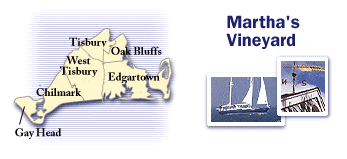
Martha's Vineyard, the largest island in New England, lies seven miles south of Cape Cod. Twenty-three miles long and 9 miles wide, the island consists of six towns: Gay Head, Chilmark, West Tisbury, Vineyard Haven, Oak Bluffs, and Edgartown.
How to get to Martha's Vineyard
Martha's Vineyard is accessible by plane or ferry.
You can also bring your car over on the Steamship Authority ferry from Woods Hole.
Travel options:
Ferry schedules |
Airlines
Getting around
Cars
If you don't bring your car over on the Steamship Authority ferry from Woods Hole you have to rent a car.
Auto rentals
Buses and shuttles
Buses run between the northeastern and southeastern areas of the island, within the northeastern towns of Vineyard Haven, Oak Bluffs, and Edgartown, and within West Tisbury and Chilmark.
There are also shuttles to South Beach from downtown Edgartown and shuttles making constant circuits within the towns of Vineyard Haven, Oak Bluffs, and Edgartown.
Community information
Chamber of Commerce
|